

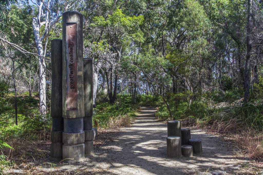
Cooloola Great Walk
Great Sandy National Park, QLD


Multi day full pack hike from Noosa North Shore to Rainbow Beach
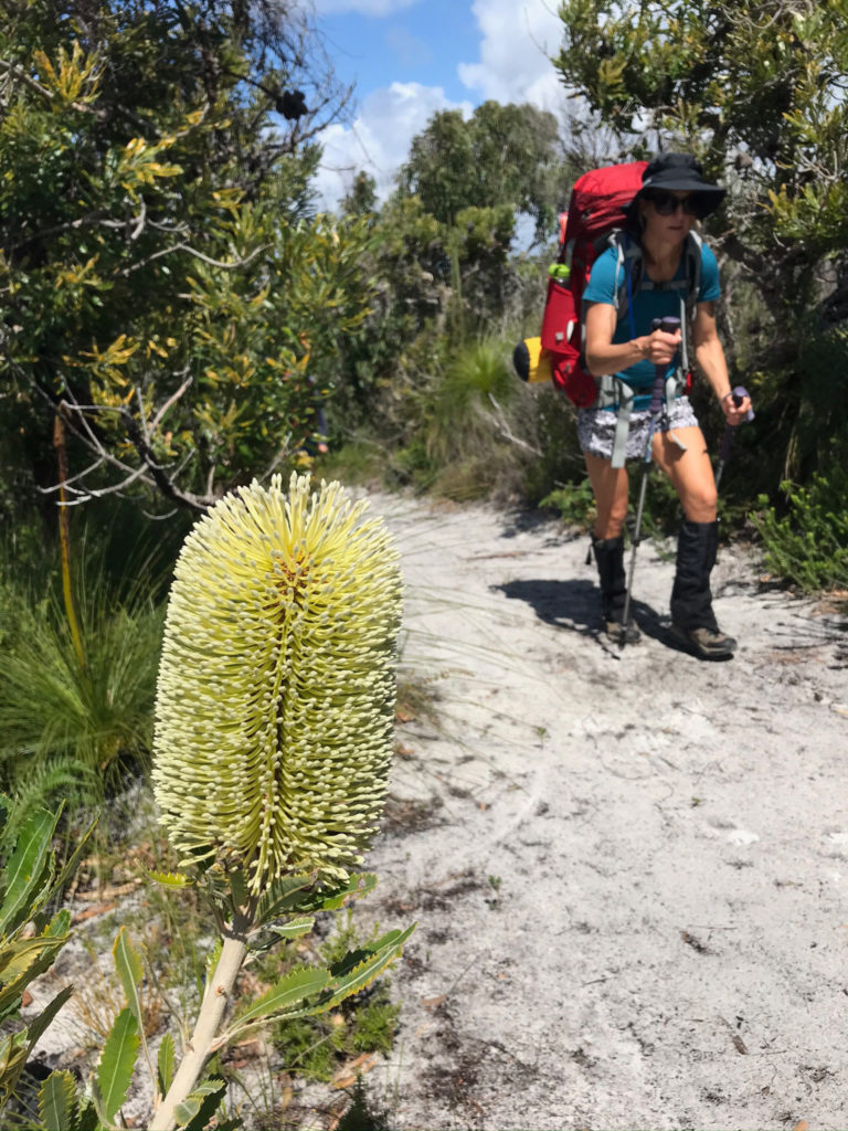
The Cooloola Great Walk is an existing 102-kilometre walking and camping trail that links the Noosa North Shore with Rainbow Beach in Queensland. Pristine beaches, huge sand blows, the rare Noosa everglades (known as the River of Mirrors for its amazing reflections), rainforests and tall Kauri trees, provide a contrast on this five-day trek through the land of the Gubbi Gubbi people and the remote Great Sandy National Park. You might be wondering what a sand blow is? A sand blow is a mass of sand that forms when strong onshore winds break through the vegetation cover, driving sand from the eroding dunes.
The trail has become more popular over time, but is still relatively quiet, since a 5-day full pack trek unsupported is generally only something a small number of people take on, plus it is remote and can only be accessed by day walkers on each end of the route if wanting to do an out and back. We met several solo hikers doing it alone. The camps were never busy with only 3 or 4 other people, and sometimes just our little group. The busiest camp is usually Kauri as it is closest in proximity to Rainbow Beach.
Cooloola Great Walk Map – 5 Day Itinerary
-

Location
Great Sandy National Park, QLD
-
Distance
102km
-
Duration
5 Days
-
When to go
April to November
-
Sleeping
Camping
-
Permit required
Yes
Trip Highlights
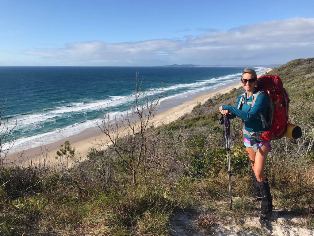
The highlights of the trek include the massive Cooloola Sandpatch, scenic Poona Lake on the last day of walking South to North, the beautiful Noosa Everglades and river and walking across to the finish over the Carlo Sandblow, to enjoy a delicious lunch in one of the local eateries at Rainbow Beach!
Our group hiked the trail from South to North in early September. Our last 2 nights and 3 days were non-stop torrential rain, so this added to the challenge! It also meant that we didn’t really get to enjoy sitting out under starry skies in those last two camps. But the first two nights were stunning and were definitely our favourite sections of the trail.
For those who love to take a dip, If you walk from south to north, your best chance of a swim is on day 1 at the beach before you head up to camp, or day 2 at Noosa river, and possibly on the last day at Rainbow Beach if you have the energy!
The Trail
The terrain is tough underfoot, and you will be hiking on a variety of natural surfaces, including but not limited to beach sand, bush tracks, roots, and boulder-strewn creeks which require you to rock hop across. Don’t expect any
The trail can be walked from South to North or vice versa. There is an additional loop that can be added on the northern section towards Rainbow Beach on the final day. It adds an additional +-15km by heading out to Double Island Point via the Kauri walkers’ camp. If you chose to do this additional section, you might also look into spending another night camping in the northern section.
The traditional inland route outlined below from Arthur Harrold Nature Refuge at Noosa North Shore to Carlo Sandblow near Rainbow Beach township is 88.1km and does not take in the extra 15k loop. Here is a day-by-day breakdown of what to expect on the 5 day Cooloola Great Walk:
Cooloola Great Walk Itinerary
Day 1: Noosa North Shore track entrance at Arthur Harrold Nature Reserve to Brahminy walkers’ camp
Distance: 17.3km
Walking time: Allow 6hrs
If you can start this really early, you can enjoy walking towards the sunrise. The first section is open heath and in the springtime has stunning wildflowers. Once you cross the road towards the beach you will enjoy some beach walking, with vast sweeping views of the Noosa North Shore. You then head off the beach just where the vehicles access the beach, but this turn is easy to miss.
It may be tempting to stay and walk on the beach, but be aware, if it is low tide, you will have to deal with speeding vehicles and if it is high tide, you may have to walk in the soft sand at the top of the beach. The trail continues behind the sand dunes and then up to a scenic view of Lake Cootharaba at what we considered our favourite campsite, Brahminy.
Day 2: Brahminy walkers’ camp to Dutgee walkers’ camp
Distance: 20.3km
Walking time: Allow 7hrs
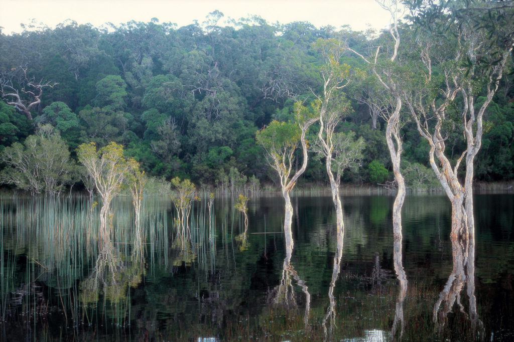
This is probably the most challenging but also rewarding day of the hike. The coastal views from the sandy track soon after leaving camp are well worth the climb. The Cooloola Sand Patch is a big hike up soft sand with a full pack, so time it carefully if the weather is hot as it is exposed. You will be pleasantly distracted from any discomfort by the scenery! Remember to drop your pack and enjoy the great views from the top of the sand patch before descending to Noosa Everglades for a refreshing swim in the river.
Day 3: Dutgee walkers’ camp to Litoria walkers’ camp
Distance: 14.8km
Walking time: Allow 5hrs 30mins
Quite a bit of climbing on this section even though it is a shorter distance, through hills and forests after leaving the Noosa river. There is evidence of the burns from the 2020 fires that came through the area. If you enjoy bird watching, you will love listening to all the different bird calls and trying to spot the species.
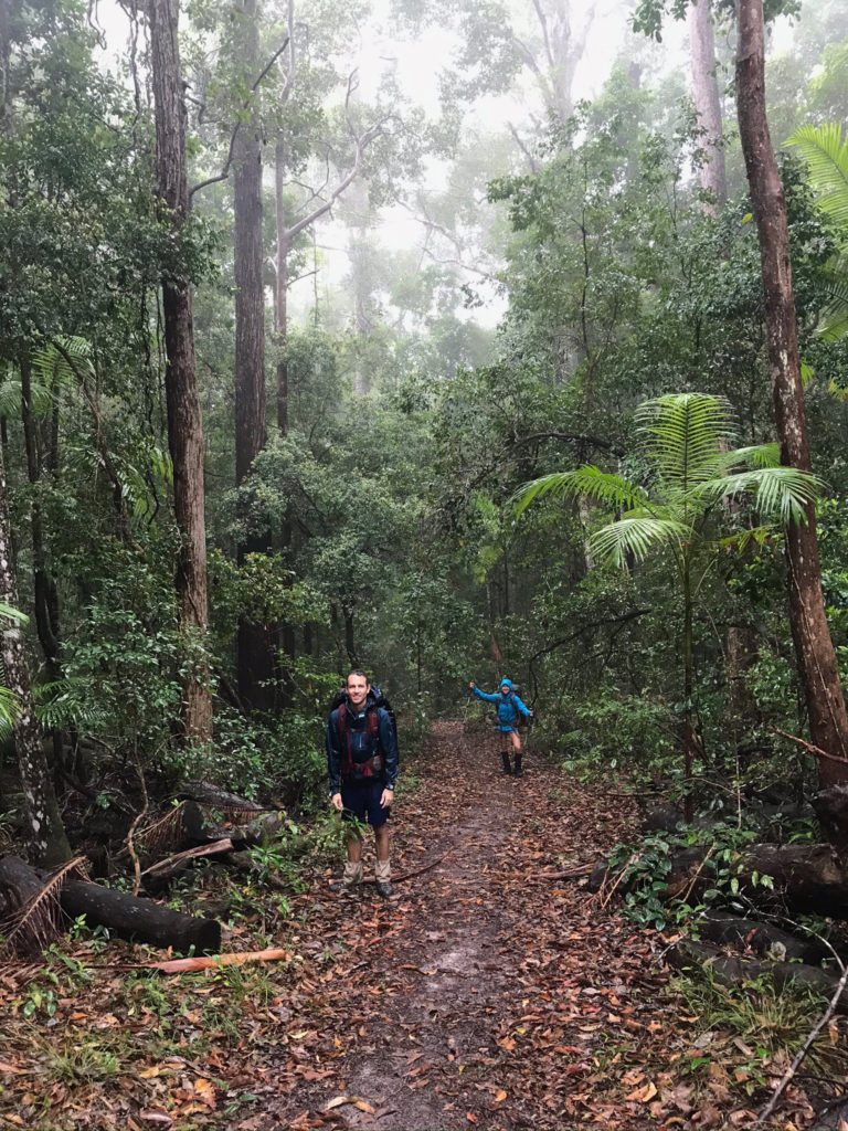
Day 4: Litoria walkers’ camp to Kauri walkers’ camp
Distance: 20.5 km
Walking time: Allow 7 hrs
This is one of the longer sections of the hike, mainly through rainforest. The camp is set in rainforest with lots of huge Kauri pines and shade.
Day 5: Kauri walkers’ camp to Carlo carpark (direct route)
Distance: 15.2 km
Walking time: Allow 5 hrs
The last section is an enjoyable walk through tall trees and the scenic Lake Poona – the highest perched lake in Cooloola at 160m above sea level. There is a very steep section to climb towards the end. Take a moment to have a photo taken on the edge of the Carlo Sand Blow, and enjoy the views, before crossing to the finish.
Facilities on trail
The official walkers camps all have long drop toilets and a water tank at each location. It is always worth making a phone call to QPWS to enquire about water availability, although we couldn’t really get a definitive answer to this. We based our decision on recent reports from walkers who had hiked the trail in the week or so before we left, and we also knew there was considerable rain forecast. We treated all the water we used from the tanks.
Each site has a couple of low wooden platforms dotted around for cooking and eating.
We had torrential rain and gale force winds the last 2 nights of our hike, so felt quite exposed being under all the big trees. By the last day, everything was damp and wet despite all our efforts to keep things in dry bags and inside the tents. There was so much moisture and humidity by then, nothing dried!
Watch out for:
- Vehicles along certain sections of the beach and the inland track, but these are few, depending on whether you are there walking on a weekend or school holiday period.
- We rang QPWS to ask about water levels in the tanks at the camp sites. No one could really confirm to us that there would be water there, but we had plenty at all the camp sites.
- There are no shops or any facilities/places to stay along the route, so you need to be FULLY self-sufficient for the entire route.
- There were some bush rats around at camp, so we tied up our food at night in dry bags on a cord/rope between trees.
- Mobile phone coverage is intermittent so don’t rely on it.
- Take sufficient charging packs for your mobile phone as there is no power to access for this and turn your phone off or on airplane mode when hiking to avoid running the battery down.
When to go
Typically hiking in South East Queensland is recommended between April and November. We hiked the trail in September which typically has some rainy periods, and the days were pleasant at around 25 C, there were some warm periods during the day, quite humid, but at night we needed long sleeves, and because of the torrential rain, our Gortex rain gear and some lightweight thermal layers – when everything else was damp and wet – were essential for keeping warm. Winter in this region is gorgeous, so for those who prefer cooler weather, aim for June-August.
Access
One of the initial challenges of organising this through-hike is making plans for your pick up on the other end. We had a friend drive to Rainbow Beach then hike in and meet us for the last 2 days and hike back out to his car to drive us back to Noosa.
Other options might include organising a taxi from Rainbow Beach back to Noosa before you go or looking into shuttle or bus services from Rainbow Beach, but be aware they may not fit in with the timing of you finishing the trail on the last day. The drive from Rainbow Beach back to Noosa is roughly 2.5 hours.
Once you begin the hike, you really need to commit to the whole distance. The trail is remote and there are few roads on the North shore that reach the trail other than 4×4 fire trails. There are no out points along the way to reduce the distance or cut it short unless you have access to a 4×4 pick up, which is discouraged.
Starting from the South at Tewantin/Noosa:
From Brisbane, it’s about a two-hour drive to Tewantin.
Drive to the QPWS Great Sandy Information Centre in Tewantin (near Noosa) and park your car there. This is also where you can get local info and maps if you are there when it is open.
Catch the ferry over the Noosa River from Tewantin, no need to pre-book the ferry.
If you decide to take your car over on the ferry to the start of the walk, be aware there isn’t really any long-term allocated parking for walkers’ vehicles, and when you return from the end of the hike at Rainbow Beach, you will then have to get across the river again to fetch your vehicle, so it is most likely better to leave your car on the Tewantin side.
Once over the river, which takes just a few minutes, it is an additional 2.4-kilometer walk along the road until you reach the trailhead at the Arthur Harrold Nature Refuge. This section can be busy on a weekend or at low tide, as many vehicles head up the North Shore at low tide.
Starting from the North at Rainbow Beach:
Rainbow Beach is roughly a 3-hour drive north of Brisbane. The most direct route is to head to Gympie via the Bruce Highway before turning onto Tin Can Bay Road and then onto Rainbow Beach Road. The track officially begins at the Carlo car park.
Accommodation
- Book your Cooloola Great Walk permit online and specify which dates you will be at each walker’s camp along the way. Carry a copy of your permit with you. Check on any special condition updates or restrictions in the area. https://parks.des.qld.gov.au/parks/great-walks-cooloola/camping
- Camping: Maximum length of stay at each walkers’ camp is one night.
- The maximum group size is six people.
- As a result of high fire danger conditions experienced over the warmer months, a seasonal restriction on bookings for Cooloola Great Walk is implemented yearly from 1 November to 31 January. High fire danger conditions pose an unacceptable risk to the safety of walkers in remote areas and some walking tracks may be closed at short notice.
Cooloola Great Walk Packing List
Your basic lightweight, full-pack camping list applies for a multi-day hike. The more experienced hiker you are, the more specific you will be about your gear and you will already have a refined list. But here’s a simple outline of the basics for those wanting a start, and you can find more suggestions on the QPWS website too. This list may vary slightly according to the season you intend to hike in. Go as light as possible, it can be a tough hike with a heavy pack!
Clothing
- Boots/trail runners (wearing)lightweight shoes for camp
- 1 pair of shorts and 1 pair of hiking pants (wearing one)
- 2 short merino/wicking/dry fit shirts (no cotton)
- Hat
- Buff
- 2 pairs of undies (test these: wicking material best, not cotton it gets wet when you sweat)
- 1 long thermal/merino top
- Waterproof/Gortex rain jacket
- Beanie
- 2 pairs of good quality hiking socks plus 1 for bed
Food / Water / Cooking Equipment
- Camping stove and fuel
- Water treatment
- Lightweight food, and snacks – enough for 4-5 days
- 2 water bottles with a wide mouth to fill from tanks
- 1 water bladder
- Potcup/mug, bowl
- First aid kit
- Matches
- 1 spork or spoon and 1 pocket knife
Nightime / Sleeping
- Head torch and spare batteries
- Pillow
- Sleeping bag
- Liner
- Sleeping mat
- Lightweight tent
Other
- Ziplock bags
- Rubbish bag
- Sunscreen
- Mosquito repellent
- Small toothbrush and paste
- Comb
- EPIRB or personal locator beacon (PLB) (check subscription requirements before you go)
- Battery and charging cable for phone/camera
- Map and track notes
- Walking poles
- Rain cover for the pack
- Dry bags
- Permits
- Money
- Small towel
- Lip balm
- Toilet paper and tissues
- Rope/cord to hang wet clothing or string up food bags overnight
Useful links: https://parks.des.qld.gov.au/parks/great-walks-cooloola
More Adventures like this
-
The Thorsborne Trail on Hinchinbrook Island, Queensland, is rated as one of the best multi-day hikes in Australia, and features in Lonely Planet’s “Epic Hikes of The World.” Just a few hours dri...
Thorsborne Trail
Hinchinbrook Island, QLD
-
Bikepacking the Queen Charlotte Track
Marlborough Sounds, New Zealand
-
Australia's most famous multi-day hike, the Overland Track is 65 km, six-day trek through the heart of the Cradle Mountain-Lake St Clair National Park.
The Overland Track
Tasmania
Related Stories
-
- our stories
7 October 2020The importance of sustainable travel
Sustainable travel takes into full account of the destination’s current and future economic, social and environmental impact so... -
- our stories
17 September 2021 |What does sustainable tourism mean anyway?
Sustainability. Environmentally-friendly. Leave No Trace. These words and more are thrown around 24/7, but what do they actually m... -
- our stories
6 October 2021 |How to find your adventure soulmates
Setting out on an adventure with friends might sound like the ideal getaway, but many have experienced the disappointment and chal...
